Monitoring Coastal Salinity and Ecosystem Resilience Using Remote Sensing and Smart Sensor Networks: A Case Study from İzmir
Coastal regions throughout the Mediterranean are increasingly facing complex environmental pressures caused by climate change, population growth, and intensive land use. Among these challenges, salinity intrusion into coastal aquifers and wetlands has become a critical issue, threatening freshwater availability, agricultural productivity, and ecosystem health. Rising sea levels, reduced precipitation, and excessive groundwater abstraction are accelerating seawater intrusion, especially in low-lying deltaic systems.
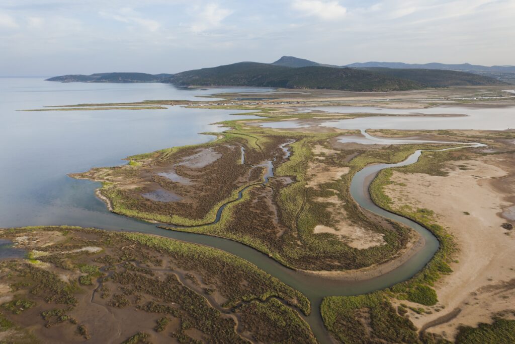
The Gediz Delta in İzmir, located along Türkiye’s Aegean coast, is one of the most ecologically valuable and vulnerable coastal systems in the Mediterranean basin (Figure 1). Hosting internationally important wetlands and diverse bird habitats, the delta is highly sensitive to changes in groundwater levels and salinity regimes. Even small variations in salinity can cause significant ecological shifts, affecting vegetation patterns, soil properties, and habitat suitability for wildlife.

Figure 1.Study Area
Despite its importance, monitoring salinity dynamics in large and heterogeneous environments remains a major challenge. Traditional field-based measurements, while accurate, are spatially limited and often insufficient to capture the full extent of temporal and spatial variability. In this context, innovative and integrated monitoring approaches are needed to better understand, predict, and manage salinity-related risks in coastal ecosystems.
Monitoring Challenges and Digital Approaches in Coastal Systems
Monitoring salinity in coastal environments is inherently complex due to the dynamic interactions between surface water, groundwater, climate variables, and human activities. Coastal aquifers are influenced by seasonal recharge, evapotranspiration, tidal effects, and pumping regimes, all of which contribute to rapidly changing salinity conditions. As a result, point-based measurements alone cannot adequately represent system-wide processes.
To address these limitations, recent advances in digital technologies provide new opportunities for large-scale environmental monitoring. Remote sensing, especially through satellite platforms such as Sentinel-2, enables continuous observation of land and water surface characteristics at high spatial and temporal resolutions.
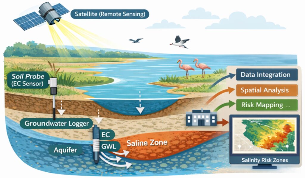
Figure 2. Integrated Salinity Monitoring Framework
Spectral indices derived from satellite imagery – such as vegetation, moisture, and salinity indicators – can be used to infer environmental conditions over large areas. However, satellite data alone cannot fully capture subsurface dynamics. Integrating remote sensing with in-situ sensor networks provides a more comprehensive monitoring framework. Field measurements, including electrical conductivity (EC), groundwater level (GWL), and other hydrochemical parameters, offer direct insights into subsurface conditions. When combined with satellite-derived datasets in a Geographic Information System (GIS) environment, these data sources enable the development of spatially continuous salinity maps and trend analyses (Figure 2).
The synergy between remote sensing and ground-based monitoring enables a shift from static observation to dynamic assessment. This integrated approach supports early detection of salinity anomalies, identification of high-risk zones, and improved understanding of the processes driving salinity change. Thus, it forms the basis of a data-driven, adaptive management strategy for coastal ecosystems.
A practical example of this approach is found in the Gediz Delta, where field measurements and satellite-based analyses have been combined to investigate salinity patterns and their relationship with environmental variables. By comparing satellite-derived indices with in-situ observations, it is possible to validate remote sensing models and enhance their predictive capability.
Implications for Climate Resilience and Relevance to Mediterranean Regions
The integration of remote sensing and sensor technologies for salinity monitoring has significant implications for climate resilience, especially in Mediterranean coastal systems. As climate change increases hydrological variability, the ability to monitor and respond to environmental changes in near real-time becomes increasingly important.
A key advantage of this integrated monitoring framework is its scalability (Figure 3). Unlike conventional methods that rely heavily on dense field sampling, satellite-based approaches can be applied across large geographic areas at relatively low cost. When supported by strategically placed sensor networks, this system provides both regional coverage and local accuracy, making it highly suitable for replication in other Mediterranean deltas and coastal aquifers.
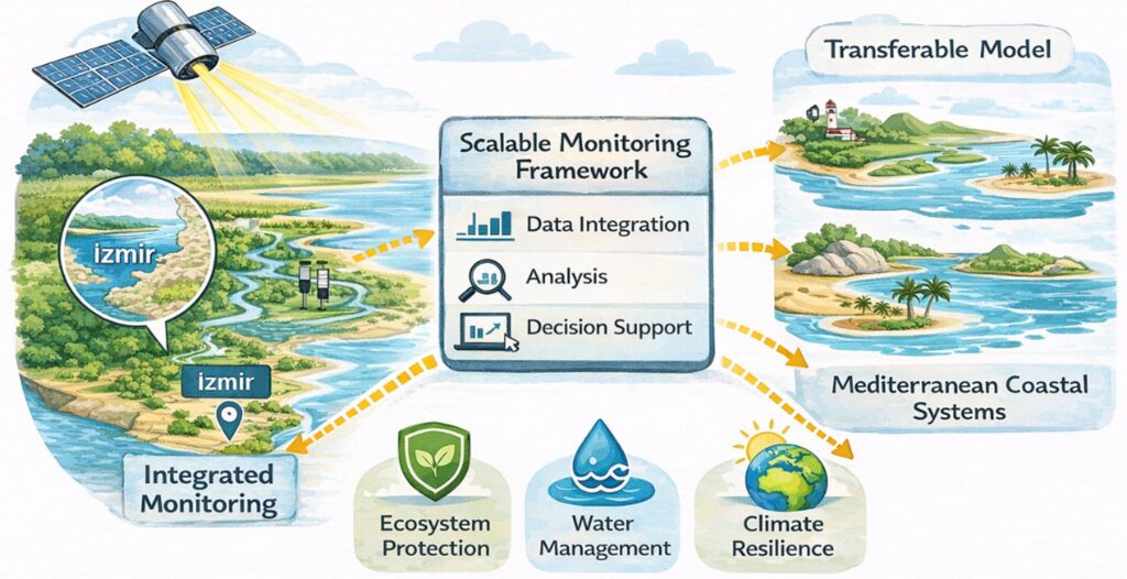
Figure 3. Scalable Monitoring Framework
From an ecosystem perspective, improved salinity monitoring directly supports the protection of sensitive habitats. Wetlands, lagoons, and transitional zones are especially vulnerable to salinity changes, which can alter species composition and disrupt ecological balance. By identifying areas at risk, decision-makers can implement targeted interventions, including nature-based solutions such as managed aquifer recharge, wetland restoration, and sustainable water allocation strategies.
This approach also aligns with the broader objectives of integrated resource management frameworks, such as the Water-Energy-Food-Ecosystem (WEFE) nexus. Salinity affects not only water resources but also agricultural productivity and ecosystem services. Therefore, monitoring and managing salinity is essential for ensuring long-term sustainability across multiple sectors.
In the context of Mediterranean cooperation initiatives, including projects such as CARDIMED, digital monitoring tools are crucial for supporting knowledge exchange and capacity building. Experience gained from applications in regions like İzmir can inform similar efforts in other coastal areas facing comparable challenges. By combining technological innovation with local expertise, it is possible to develop adaptable and resilient solutions tailored to diverse environmental conditions.
Conclusion
The increasing pressure on coastal ecosystems in the Mediterranean highlights the urgent need for innovative monitoring and management strategies. Salinity intrusion, a key indicator of environmental stress, requires approaches that move beyond traditional observation methods and adopt integrated, data-driven solutions.
Combining remote sensing with smart sensor networks offers a powerful tool for understanding and managing salinity dynamics in complex coastal systems. By bridging the gap between large-scale observation and local measurement, this approach provides more accurate, timely, and actionable insights.
The case of the Gediz Delta shows how integrated methodologies can support ecosystem resilience, inform policy decisions, and contribute to sustainable resource management. As climate challenges continue to develop, scalable and transferable monitoring frameworks will be essential for protecting Mediterranean coastal regions.
The shift toward digital and integrated environmental monitoring is not only a technological advancement but also a necessary step toward achieving long-term climate resilience and ecological sustainability.